Between May 18 and July 5 of 2023, I walked from The Hawk on Cape Sable Island, the southern tip of Nova Scotia, to its northern tip at Cape North on Cape Breton Island, a 1000+ km trek. This is the story of part of that journey. See these posts to read about the whole journey:
- Cape to Cape #1 – Getting Ready
- Cape to Cape #2 – Cape Sable to Halifax
- Cape to Cape #3 – Halifax to Moser River
- Cape to Cape #4 – Moser River to Port Bickerton
- Cape to Cape #5 – Port Bickerton to Port Hastings
- Cape to Cape #6 – Port Hastings to Inverness
- Cape to Cape #7 – Inverness to Cape Breton Highlands National Park
- Cape to Cape #8 – Cape Breton Highlands National Park to Cape North
A big thank you to everyone who has bought me a coffee over the past year. The Buy Me a Coffee service allows patrons like you to fund writers like me, to cover things like the costs of running this blog, new shoes and gear, and journeys like this. If that sounds like a worthy idea to you, then go ahead – keep buying me coffees.
Where am I now?
On the road, at Norse Cove Campground outside East Ship Harbour, where I am camping for the night the Marmalade Motel in Port Dufferin the Liscombe Lodge in Liscomb Mills. (Started this post a couple of days ago and am trying to finish it, I swear!)
This 3rd leg of my journey along the Eastern Shore began on June 6 in Halifax at the Ferry Terminal. At time of writing (June 10 June 13 June 14) I’m about 100 150 165 some odd km from Halifax, and almost have just passed the halfway point of the journey.
Places

I had never taken the ferry to Dartmouth before, so it was fun and vaguely reminiscent of taking the ferry in Sydney, to board it that morning.

After landing, I was off and since then I’ve passed through Dartmouth, Cole Harbour, Lawrencetown, Porters Lake, Musquodoboit Harbour, Head of Jeddore, Salmon River, Ship Harbour, East Ship Harbour, Spry Harbour, Spry Bay, Mushaboom, Sheet Harbour, Port Dufferin, East and West Quoddy, Moosehead (isn’t that a Bluenose name!), and Moser River.

And it’s a bit of a story but given a persistent day of rain, instead of stopping and camping in Moser River and then walking on to Liscomb Mills the next day, as I had planned, I decided not to be a martyr; instead I booked two nights at Liscombe Lodge, walked to and stopped at Moser River in driving rain, got picked up by a nice guy named Doug who drove me to the Lodge, and am now lording it in a fancy dining room having a glass of wine looking out over the Liscomb River at misty, rainy, low fog under which I might otherwise have camped, on sodden grass. So there.
But to get back to the journey.
The character of the Eastern Shore is different from the South Shore – more rural, more rugged, and less populated. Almost the entirety of this leg of my journey has been road walking, and since Musquodoboit Harbour it’s been along Highway 7.

I have diverted a few times along some back roads, but for the most part what I see has been determined by whether the road is near the coast or whether it veers inland.

So it’s road walking, which can mean brain-off slogging sometimes, but also offers the little serendipitous scenes that catch the eye as you walk.
Like passing a farm where the washing was out on a line, all black clothes, except for a lime green shirt in the middle.
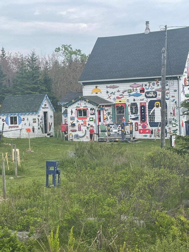
Or some of the interesting mail boxes I’ve come to expect.

Or the ghost stairs that are the only remaining part of what had been a house.

And I’ve kept myself amused noting some of the road signs I’ve passed, some for businesses

And some for other things

As places go, Sheet Harbour is the town that sticks out for me. The only other town since Dartmouth that actually felt like a town was Musquodoboit Harbour, and even it didn’t have the shops and restaurants and varied businesses that make a town a living entity.
Sheet Harbour in that sense is a proper town with a library and a hospital and a big school, and parks, and actual sidewalks. I liked it more than I thought I would.
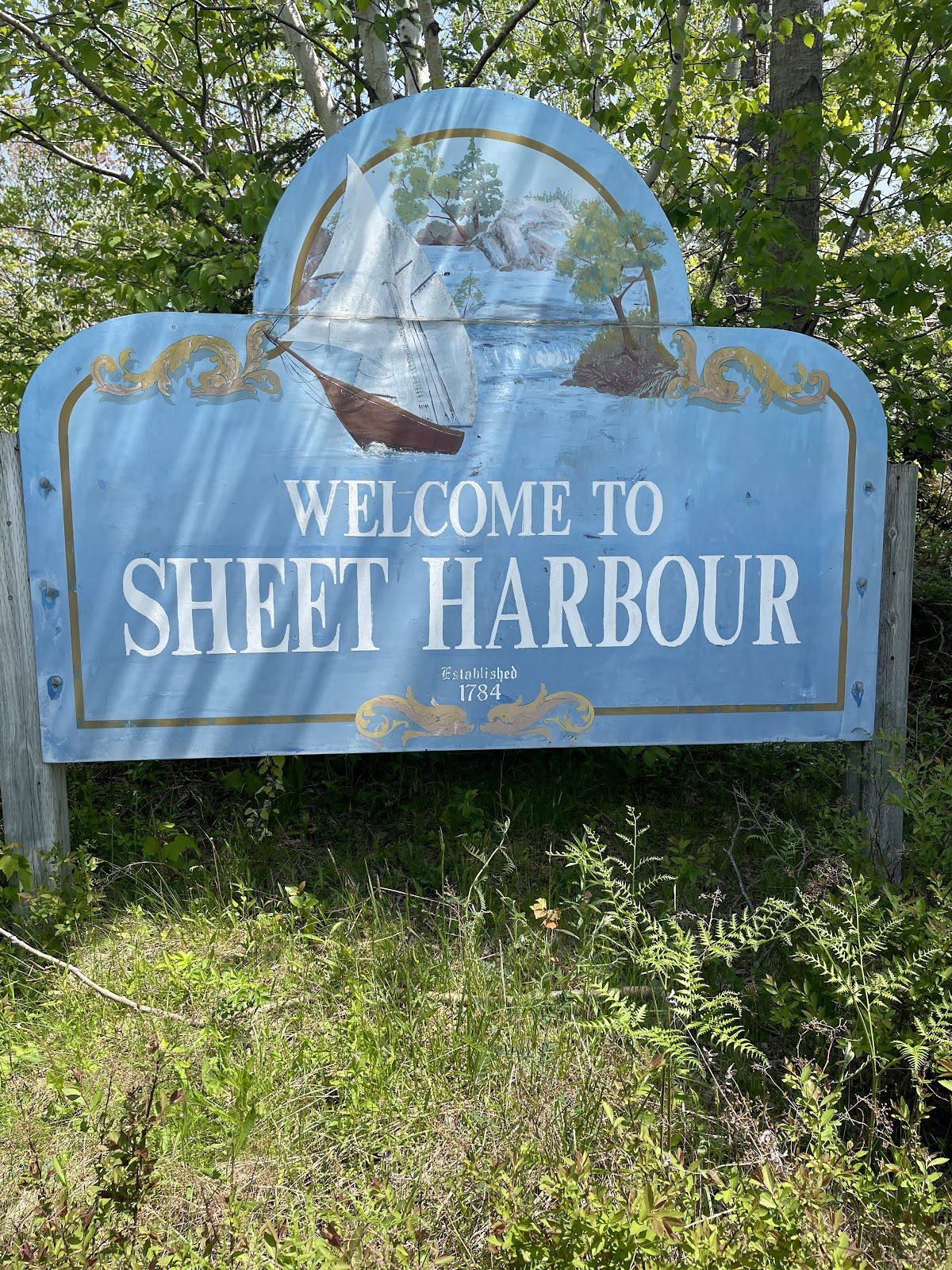
That’s probably because I met a number of interesting people there, from the hardware store manager who gave me directions to a good cafe, to the firefighters who stopped to chat about my journey when they saw me walking past with my pack.
So thank you Sheet Harbour. But next time, you can keep the black flies to yourself.
Sleeps and Eats
So far on this leg of the journey, I’ve had a range of accommodations. I’ve camped 4 times, once at Porters Lake Provincial Park, where I was the only camper in the whole place making for a spooky evening as the fog rolled in off the lake and the crows gathered to glower at me from the trees surrounding my tent.

I’ve also camped 3 times at private campgrounds including Norse Cove, Spry Bay Campground, and East River Lodge and Campground.
Spry Bay and East River were fine, though they cater primarily to RV campers. I was the only tenter at either one, which was good for me since it meant that no one else was using the washrooms, and being early in the season both were almost empty and very quiet. I slipped in, set up, slept, and slipped out without much fuss at either place.
Norse Cove was cool because it’s almost entirely a tenting campground, and the sites are set into the forest on platforms so you get a level space for your tent and a view of the bay in front of you.

The campers there are much younger than at the RV resorts – very different demographics – and the vibe is very laid back. I met a young woman there who was friends with another woman who had inadvertently overheard me explaining my journey on the phone. She stopped to chat as I was charging my devices, curious to know more. I explained where I was going and she wished me good luck and safe travels. And it turned out that her friend was from Lahave, just up the road from Lunenburg. I love small world moments.
I’ve also had a couple of AirBnB stays, including a simple but spacious and comfortable basement apartment near Mineville hosted by Andrew, on my first night out of Dartmouth, which had a private deck overlooking his green oasis of a garden.

Plus, a great glamping tent stay on a quiet lake hosted by Kim and Mark – I loved the fact that I got the closeness to nature of camping but someone else dealt with the tent and provided a much comfier bed than I use backpacking.

And finally I’ve had a couple of stays at little inns. The Salmon River Country Inn is run by Margit, originally from Bavaria, so it has a German country inn feel which reminded me of trips to Munich.

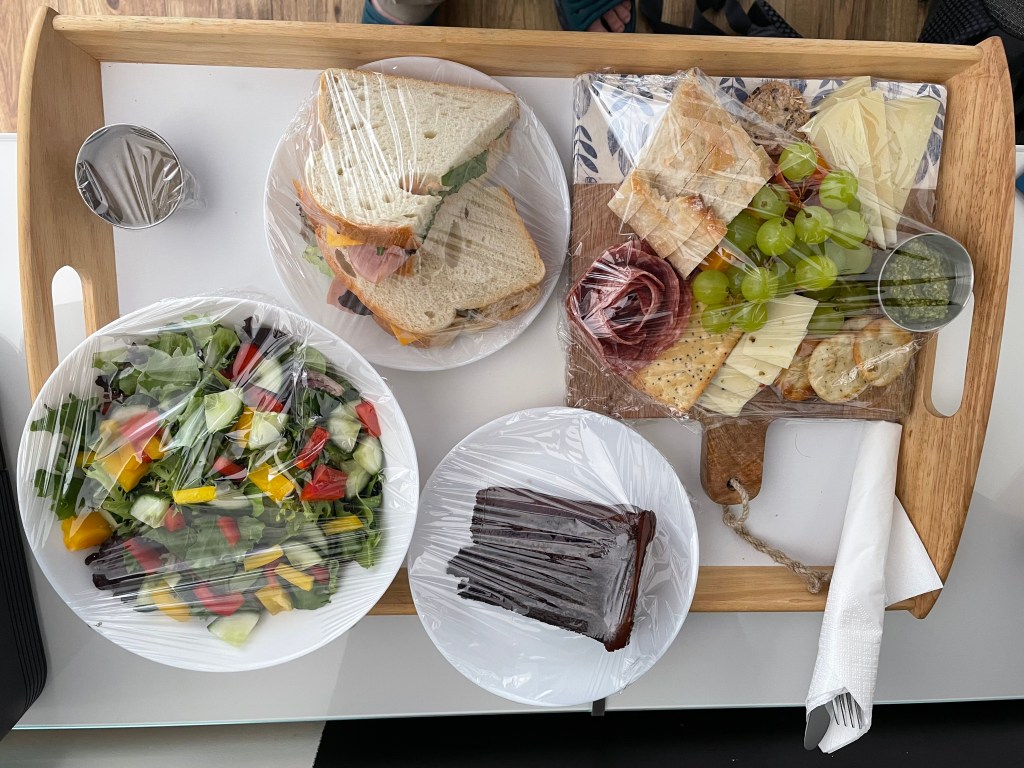
And then there was the Marmalade Motel, once an old school motel and now a fully renovated and eclectic little gem, full of character and designer chic. And when I arrived at the Marmalade, I got the bonus of a wedding going on outside

(part of this post was written while I was being serenaded by the wedding party singing karaoke – Gangnam Style, Dancing Queen, etc – badly and with much laughter).
And tonight I am at one of Nova Scotia’s classic country inns, the Liscombe Lodge, old school perhaps but charming and staffed by lovely warm people who call you Hon.
*****
Along the way, I’ve had some memorable meals as well. My glamping tent hosts, Kim and Mark, run a restaurant and pantry called Lupin, and even though the restaurant wasn’t open when I was there, Kim cooked one of her take-home-pantry chicken and broccoli casseroles for me – simple comfort food done well.
And Margit at the Salmon River Country Inn does Bavarian favourites, so naturally I had chicken schnitzel, traditionally prepared and perfectly served, still sizzling, accompanied by the simple potato and cucumber salads I remember from my visits to Munich.
Uprooted Market and Cafe in Musquodoboit Harbour serves great coffee, makes a tasty vegetarian egg breakfast sandwich, and offers a pretty darn fine oatmeal cookie.

I’ve eaten my share of room service club sandwiches at hotels all over the place, when I travelled on business back in the day, and Ralph’s Down East Diner does theirs really well. And the fries are great too.
The Marmalade Cafe in Sheet Harbour is another good spot for coffee, plus they do breakfasts, sandwiches, salads, and soups.
The Slippery Oyster, also in Sheet Harbour, served a surprisingly tasty chicken quesadilla, not something you find on many Nova Scotia menus.
And the Marmalade Motel offers picnic lunches and continental breakfasts. I ordered the picnic as my dinner and was amazed and delighted to be served a massive tray of tasty food that really hit the spot after a day of walking.
The Liscombe Lodge offers its signature planked salmon as well as classics like steaks, chicken supreme, and Caesar salads, but even if the menu is stuck in 1985 and looking around I see that I’m one of the younger people here, the food is prepared with care and is comfortably part of my culinary past, the wine is good, and the atmosphere is relaxed and welcoming.
And of course, since I’ve camped several times, I’ve also had a few backpacker meals. My staples are things like oatmeal for breakfast

or just-add-hot-water things like Raman noodles.

And camping has offered the bonus of being eaten alive by mosquitoes and black flies. Nothing says Yum like slurping noodles with one hand while holding your bug net off your face with the other.
Stories
Oh my, the stories. As this journey has unfolded, it seems the people and stories have gotten better and better.
I stopped at Ship Harbour at the only restaurant between Salmon River and Norse Cove – Ralph’s Down East Diner. I walked in, wearing my pack, and all eyes swiveled onto my sweaty figure. No one said anything at first, just watched as I put my pack down and ordered. And then the one guy who’s in every room said loudly enough for the whole place to overhear, “So where’d you walk from?”
“From Salmon River this morning. I left Dartmouth 5 days ago.”
“Where you headed?”
“Cape Breton. I’m walking the length of Nova Scotia, headed for Cape North.”
“Are you? Good for you.”
And then as the guy was leaving, he said “Good luck buddy, and stick to it.” You know you’re down east when someone calls you Buddy.

*****
And just after I left that diner, I passed a house where two young boys, maybe 9 or 10, were out playing on the front porch. They looked up as I passed. The bold one called out, “Did you walk from down there?”, pointing back along the road.
“Yep. From Halifax.”
“Really?”
“Yep.”
“Where are you going?”
“Cape Breton.”
Shock, eyes growing wide and a disbelieving glance at his friend. After a moment to pick up his jaw, he blurted out “Why?”
“To explore, to see things. That’s how you learn, by exploring.”
Dubious shake of the head, another quick glance at his friend. “Good luck, mister.”
“Thanks.”

*****
Sheet Harbour offered a wealth of characters. There was the owner of the East River campground, who asked about my journey, and after we got to chattin’, offered to give me a lift to a local restaurant and then stayed to have dinner with me. We talked for an hour about travelling, life in general, and just doing things while you can and are able – we were both of a certain age. Afterwards he gave me a guided tour of the town and shook my hand as we parted – “good luck”.
Then the next morning I went to the Marmalade Cafe for breakfast. I spent an hour reviewing my upcoming plans while eating, as regulars came and went. When I got up to leave, and walked over to where I’d left my pack, two women came up. “Where are you off to then?”
“Cape Breton.”
“Are you now. Where did you start from?”
And then after a few minutes of chit and chat as I explained my journey, they asked where I was heading next. “Port Dufferin to the Marmalade Inn tonight, and then somewhere around Moser River, but I don’t know where I’ll stay that night.”
More chat and suggestions and conferring between themselves and offers to call a friend to see whether I could camp on so-and-so’s land, and several other suggestions. Finally, I said thank you for their advice and we wished each other well. “Keep going, you’ll do it”, they said.
And then, after they’d left, I turned to pay for my breakfast. “It’s paid for”, said the server. “Those two ladies took care of it“. So thank you, the Ladies of Sheet Harbour Who Frequent The Marmalade Cafe. I’m smiling as I write this.

Where next?
The immediate next step is to go back to Moser River, then walk to Liscomb Mills as I’d planned and keep going along the Eastern Shore. Once I reach Sherbrooke, I can finally get off of Highway 7. I’ll follow Route 211 for a while and then at Isaac’s Harbour I’ll connect with Route 316 which will take me to Larry’s River.
Oh, and here’s another story. At Larry’s River, a treat is in store. In booking my stay at Murphy’s Inn, I was corresponding with the owner, Bob. I explained about my journey, and he in turn was interested enough to chat about it with others in the area. The upshot is that he’s arranged to have me invited to a lobster supper, with chats with several local historians and fellow guests interested in the history of the area and the Inn, and on top of that I’ll be interviewed by the local paper. Thanks Bob, I’m very much looking forward to it.
And that’s really the story of this journey, it’s been about meeting great people – the finest kind.
Thank you, Nova Scotia.

Route
Here’s the original plan. I have more or less followed it as written until part way through Step 9, where I had to move off the trail, skip steps 10-13, and just followed the road from East Chester and through Halifax (step 14).
This latest bit has seen me start at Step 15, for Step 16 followed route 207 instead of the trail, did step 17, and am now in the middle of a step 18. After that, it’s still more or less the plan as described.
Start atThe Hawk on Cape Sable Island, and follow coastal roads to reach Barrington Passage.Pick up the Shelburne County Rail trail and follow it to Clyde RiverThen walk along the tedious Highway 103 toShelburneWhere you’ll get back onto the rail trail to walk toLockeportAnd then from Lockport, continue following the rail trail through and past theTidney River Wildernessarea to reach Highway 3 atSummerville.Where you continue on the highway for a bit and then get back onto the rail trail to reachLiverpoolAnd then continue on the rail trail up to around Port Medway, before exiting onto Route 331, the Lighthouse Route coastal road, to walk all the way toLeHave.From LeHave, take the ferry over the river and walk toLunenburgon the local back roads, and thenFrom Lunenburg, take theRum Runners Trailthrough Mahone Bay, past Chester, and on past Hubbards to Upper Tantallon, and thenDetour south onto the Joshua Slocum Trail to reach old dirt roads through Five Bridges Wilderness Area to reach Glen Margaret, where youPick up Route 333, the Peggy’s Cove Road, to walk down to thelighthouse, and then bear east towards Prospect to connect withThe Old Halifax road which takes you north back to Glen MargaretWhere you connect onto the old St. Margaret’s Bay Road to walk east to HalifaxAnd then walk through the city to the ferry terminal.- There you catch the ferry over to Woodside in Dartmouth
- To reach the Shearwater Flyer rail trail, which takes you northeast to Lawrencetown
- Where you follow back roads to Porters Lake and then onto Highway 7 to reach Chezzetcook,
- And then keep following Highway 7, past Musquodoboit, Jeddore, Ship Harbour, Spry Bay, Sheet Harbour, Moosehead, Ecum Secum, and Liscombe, all the way to Sherbrooke.
- Where you turn onto Route 211 and follow the coast road northeast to Isaacs Harbour, and then
- Branch onto Route 316 and follow that to Larry’s River.
- At Larry’s River, you follow (natch), Larry’s River Road north to reach Highway 16 outside Guysborough,
- And Highway 16 takes you to Boylston where you get onto Route 344, which
- Bears northeast and then north and then west, around the coast to Aulds Cove, where the TransCanada Highway Canso Causeway clambers across to Cape Breton Island.
- You feet fall onto the Celtic Shore Coastal Trail, and follow that all the way to Inverness.
- From Inverness, follow Highway 19 to Dunvegan and then branch onto Route 219 along the coast to Margaree Harbour.
- Pick up Highway 30 and follow that to Cheticamp, and Grand Etang where you’ll enter Cape Breton Highlands National Park.
- Follow hiking trails, including the Skyline Trail, northwards before rejoining Highway 30 again.
- Continue along that north until you reach Fishing Cove, and detour there down hiking trails to the water.
- Retrace your steps back to Highway 30 (the Cabot Trail) and follow it north to Pleasant Bay
- Turn the corner and follow the Cabot Trail east, up across the island past Big Intervale and Sunrise to reach the hamlet of Cape North (not the actual Cape North, just yet).
- Turn onto the Bay Saint Lawrence Road and follow that to Bay Saint Lawrence.
- Follow the Money Point Road to reach your goal, the lighthouse at Cape North!
- Walk back to Bay Saint Lawrence and meet your darling wife who will drive you to Baddeck for a well-earned rest

If all goes well, I’ll finish in early July 2023. More blog posts to follow, of course.
Like what you read? Buy me a coffee. Your donation helps offset the costs of maintaining this blog.

That is a Long walk. I’ve written about the Hawk beach and camping and hiking at Meat cove,. Plus I’ve pretty much visited most of the province in between. Best wishes and good luck. I’ll follow along.
LikeLike