Between May 18 and July 5 of 2023, I walked from The Hawk on Cape Sable Island, the southern tip of Nova Scotia, to its northern tip at Cape North on Cape Breton Island, a 1000+ km trek. This is the story of part of that journey. See these posts to read about the whole journey:
- Cape to Cape #1 – Getting Ready
- Cape to Cape #2 – Cape Sable to Halifax
- Cape to Cape #3 – Halifax to Moser River
- Cape to Cape #4 – Moser River to Port Bickerton
- Cape to Cape #5 – Port Bickerton to Port Hastings
- Cape to Cape #6 – Port Hastings to Inverness
- Cape to Cape #7 – Inverness to Cape Breton Highlands National Park
- Cape to Cape #8 – Cape Breton Highlands National Park to Cape North
A big thank you to everyone who has bought me a coffee over the past year. The Buy Me a Coffee service allows patrons like you to fund writers like me, to cover things like the costs of running this blog, new shoes and gear, and journeys like this. If that sounds like a worthy idea to you, then go ahead – keep buying me coffees.
Where am I now?
Cheticamp. I arrived yesterday (June 29) and am spending two nights here.

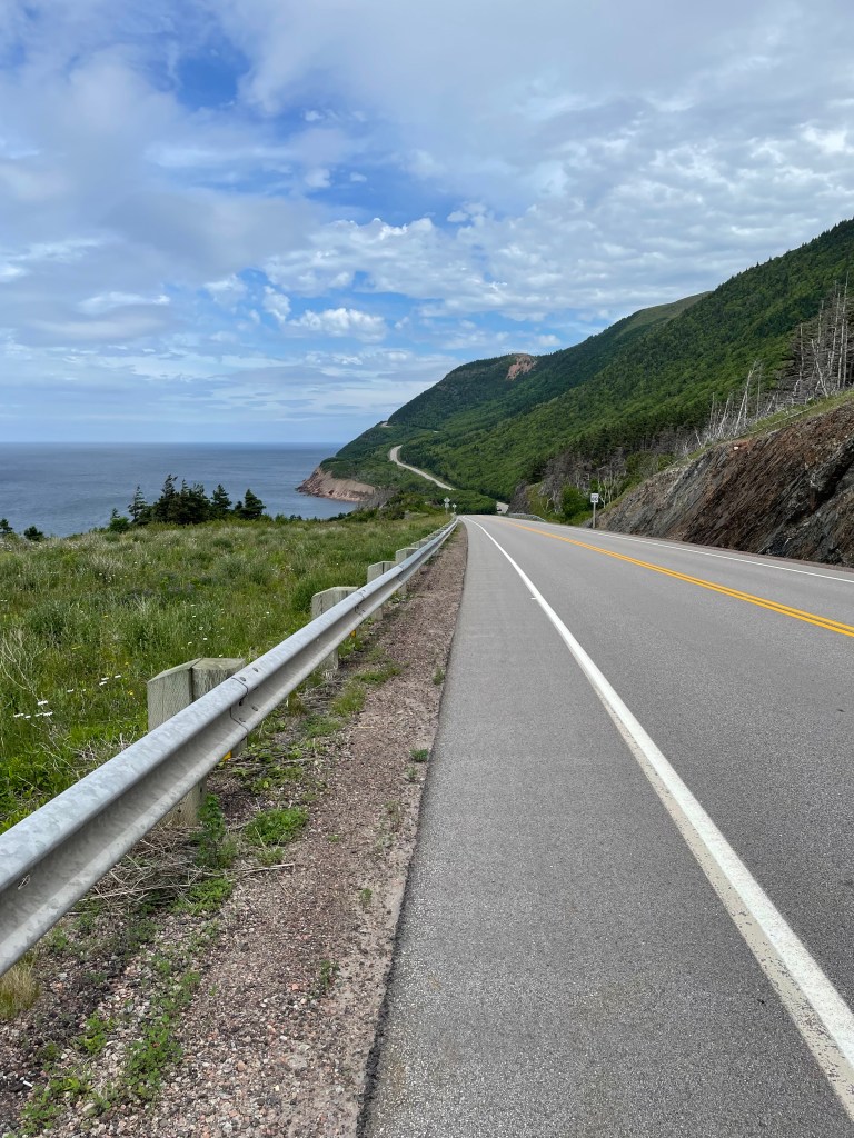
To get here, I left Inverness and followed Highway 19 for a bit before turning off onto a Shore road, the Broad Cove Marsh Road, a decision that was rewarded with some amazing views down the coast and over the water.

This took me to Dunvegan, where I joined Route 219 for a tedious, humid, misty/rainy, sweltering slog to Whale Cove, (though I did get a nice sunset there),

and then on to Margaree Harbour. I picked up the Cabot Trail here,

after a short detour (let’s not call it a navigation mistake) through the town past the harbour and a lovely white wooden church

and back to the highway. The road crosses the Margaree River and the wind that day was blowing from the right direction to cause the steel bridge structure to hum like a wind chime, holding a note which brought to mind the long E-major piano chord at the end of the Beatles’ A Day In The Life.

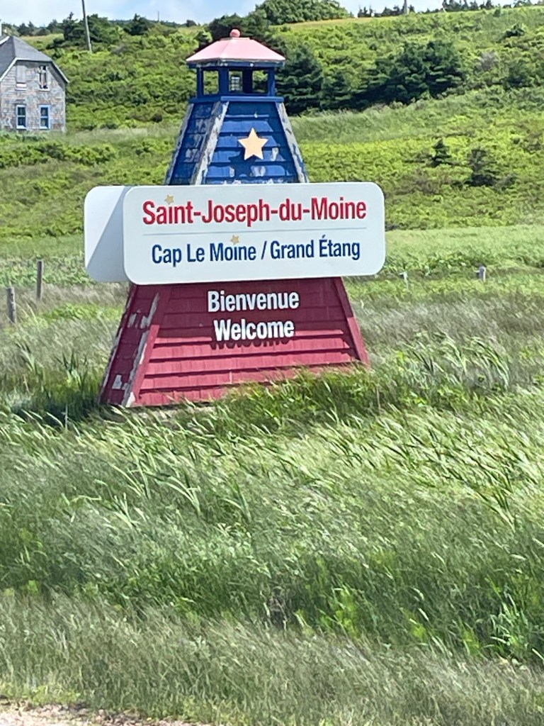
After that, it was road-walking along the Cabot Trail all the way past St Joseph du Moine, Grand Étang,
and finally into Cheticamp. It was a gusty, windy day, and with my pack acting like a sail I was blown off balance several times. And the wind played more music, as it set the overhead wires singing and the long grasses swaying.
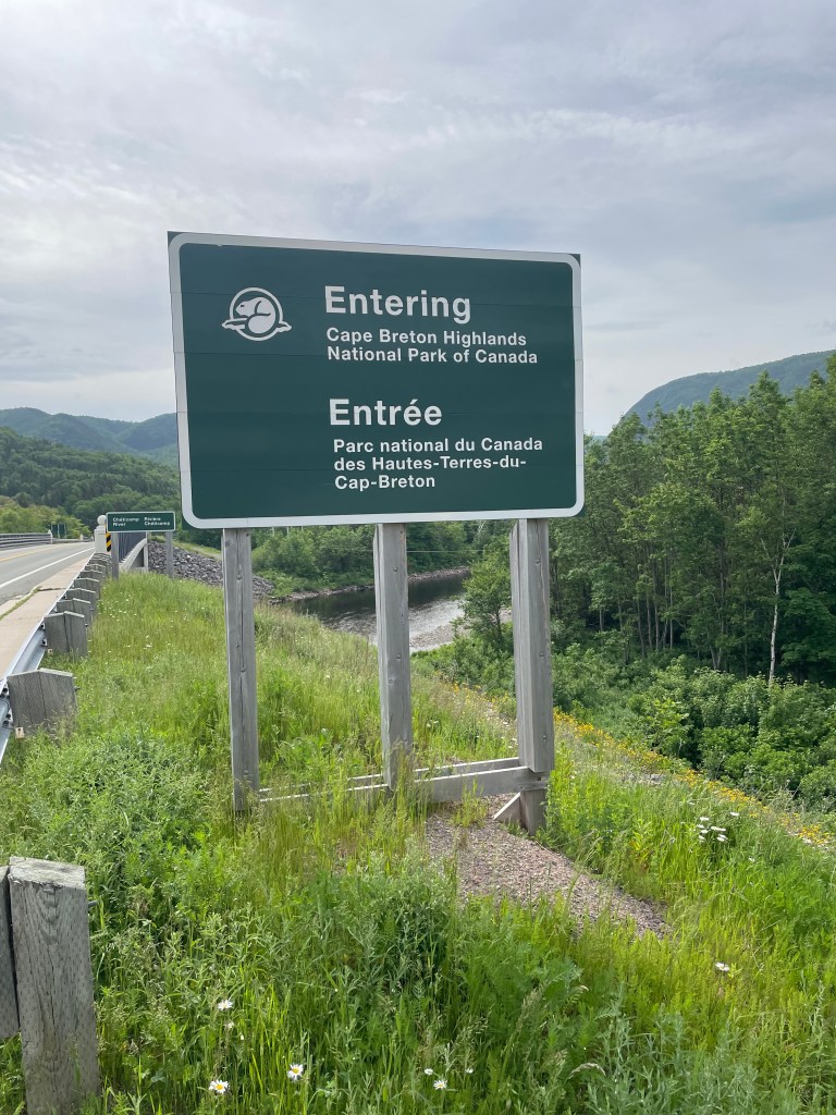
And then today (June 30) I walked out from the town, about 6 kilometres to reach Cape Breton Highlands National Park.
Almost immediately, I was rewarded by the sight of a young beaver swimming in a small pond next to the road,

a sight that makes me feel extra Canadian on the eve of Canada Day.
Soon after that little shot of Canuckness, I turned off the road and followed a couple of the hiking trails – the Chemin du Buttereau

and the Vieux Chemin de Cap-Rouge, both of which trace the old roads used by the Acadian settlers who lived in the area prior to the creation of the park in 1936.
They were similar in terms of scenery, I.e. you didn’t see much other than the forest that’s regrown over the land
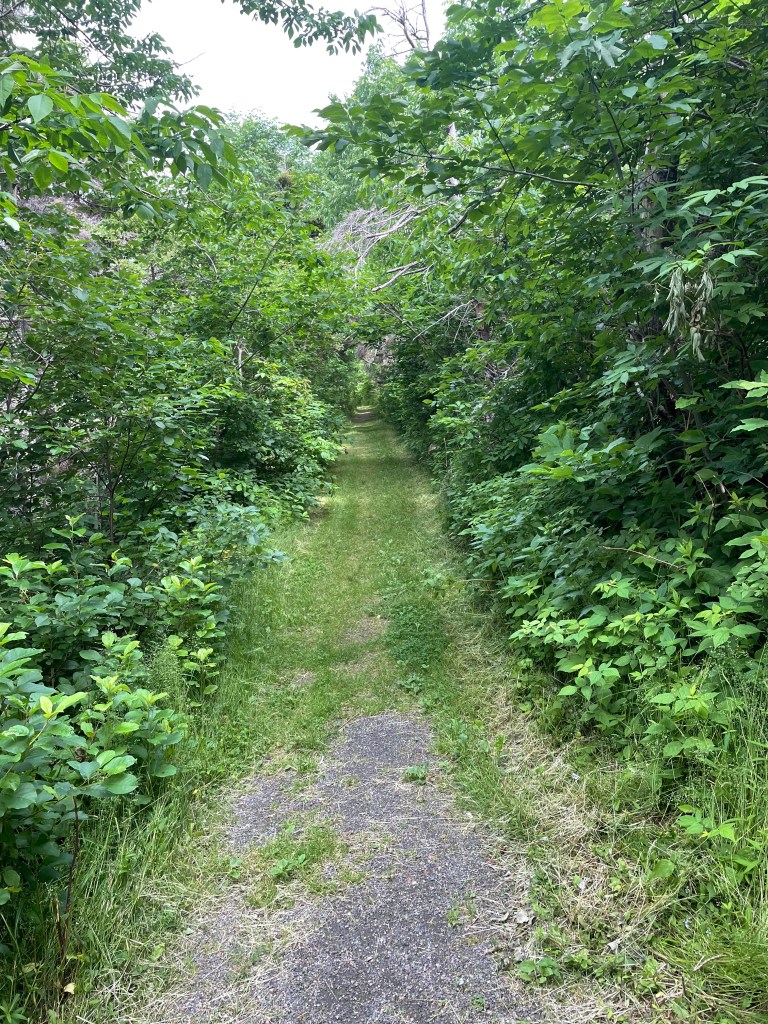
since the Acadians’ land was expropriated for the park, but that’s a reminder of the reason today’s Nova Scotia Acadian population still holds deep feelings about the many ways they were shoved about since 1748 as pawns of first the colonial and later the provincial powers.
Together these two trails took me to about Cap-Rouge, and from there I slowly climbed the Cabot Trail highway
past the veterans monument that always brings a tear to my eye – there is one of these placed in a national park in every province. I took my hat off and stood quietly for a moment.

And after that moment was ended by a family of three driving up and taking pics of each of other with the coastline in the background, I trudged onwards, relentlessly up and up and up.
Rounding a corner, I could see small windswept little trees hugging the top of the next mountain, and then realized the trees were moving – I was looking at other hikers exposed above me as they did the Skyline Trail.
I ended the day when I reached the parking lot for that trail, and cursed a bit that I wasn’t able to hike it – I would have liked to have done but since it’s a loop that takes 3-4 hours to do, it doesn’t get me closer to my finish. Another time.
Here are the stats so far:
- Total kilometres walked – 956
- Total # of days spent walking – 40
- Total # of steps walked – 1,297,000+
- Total # of hours spent walking – about 243
- Total # of stairs climbed according to FitBit – 4148
Sleeps and Eats
Hmm, less to tell here. The AirBnB in Cheticamp is quite nice and centrally located in town near the grocery store. As a result I am enjoying two nights of my own cooking, along with some nice Nova Scotia wine.
That’s with the knowledge that the remainder of this trip will be backpacking food – ramen, couscous, oatmeal, dried fruit, pumpkin seeds, and turkey jerky. Yum!
The stay at Whale Cove is best left alone on the theory that if you can’t say something nice then don’t say anything at all.
And beyond that, I’ve only stopped at one place for lunch, the Belle View restaurant in Belle Cote just outside Margaree Harbour. They make a perfectly respectable breakfast, which kept me going for a few hours.
Stories
As I was taking a water break at a little photo op spot on the Cabot Trail outside Belle Cote, a cyclist came in for a quick water break as well. I walked over to her. “Where did you start this morning?”. “Dingwall”, she said. Holy crap, I thought, that’s at least 90 km from here, and she’s not even sweating, as I looked down at my soaked T-shirt.
“Good ride? At least it’s downhill for you from that direction”.
“Yes, but this headwind (she was going south) is annoying. It was so strong it pulled my helmet back and strained my neck.”
“Well, on the bright side”, I said in a voice that would have had my son rolling his eyes at my Dad tone, “at least it keeps the bugs down.”
“Thanks for that positive spin”, she said, and sped off nonchalantly towards Baddeck, another 50+ km in front of her, and she still wasn’t sweating! Lord, to be young.
And then 5 minutes later a guy on a cycle passed me, whom I assumed to be her partner. He was grunting uphill into the wind as we met, and I shouted out “you eat headwinds for breakfast!” If he was her partner, I pictured them comparing notes at the end of day and joking about the old guy they’d seen backpacking.
*****
When I got to the Park, I went into the visitor center to see if there was anything they could tell me about walking through. I explained what I was doing to the young guy behind the desk. He got up and had a quick chat with his colleague. “This guy is walking through the park. What pass does he need?”, I overheard. “Why?”, she asked. More huddled conversation. He came back, and after some fiddling decided that I needed a three-day visitor’s pass, but since the next day was Canada Day which was free, and the next day was Sunday which think he said was also free, charged me $8.50 for a one-day pass. I guess they don’t get a lot of foot traffic.
*****
Because I was staying in Cheticamp again after walking partway through the Park, I had arranged for a ride service to pick me up at the end of the day’s walk and bring me back to town. The driver pulled up and I put my stuff in and climbed into the front seat. We got chatting.
“So where did you start from?”
“This morning from Cheticamp, and overall from Cape Sable Island. I’m walking the length of Nova Scotia.”
“How old are you?”
“I turned 60 this year”.
Glances, gives me a once-over. “Crap”, he thinks to himself so loudly I can hear it, “he’s in better shape than I am and I’m younger than he is”.
We natter for a bit about training and exercise and then I said that really this trip was about the journey, exploring the province. I explained that I’d resolved to find at least one moment every day when things are peaceful and calm, to remind myself that there’s always a good moment if you stop to notice it when it happens.
He looked at me and nodded, then shared a very personal story of loss, and I could only say how sorry I was. He shook his head – “Thank you for telling me that, about finding that moment every day. That helps.”
We got to my place and I tried to give him a tip along with the fee. “Keep it. Just don’t charge me for the therapy you just provided”.
We shook hands as I got out, and I was reminded again that the people I meet on this journey are the best reason for doing it.
Where next?
Looking at my plan, I have less than a 100 km to go, though there is more than 4000m of climb and descent in that. Ann texted to remind me that I am now 5 sleeps from my goal. It’s hitting me now, I’m close.
From tomorrow it’s two more days to finish walking through the Park, then on to Cape North the town and turn left towards Aspy Bay for a night, then keep going up to Bay St Lawrence to sleep if I can on the last night, and then it’s up over the mountain to the Cape North lighthouse for a selfie before a return climb over the mountain to Bay St Lawrence. Et Finis.
Route
Here’s the original plan. I have more or less followed it as written until part way through Step 9, where I had to move off the trail, skip steps 10-13, and just followed the road from East Chester and through Halifax (step 14).
This latest bit has seen me complete Steps 25-27, though I have to skip Step as I can’t go to Fishing Cove so from here it’s onto Step 29. After that, it’s still more or less the plan as described.
Start atThe Hawk on Cape Sable Island, and follow coastal roads to reach Barrington Passage.Pick up the Shelburne County Rail trail and follow it to Clyde RiverThen walk along the tedious Highway 103 toShelburneWhere you’ll get back onto the rail trail to walk toLockeportAnd then from Lockport, continue following the rail trail through and past theTidney River Wildernessarea to reach Highway 3 atSummerville.Where you continue on the highway for a bit and then get back onto the rail trail to reachLiverpoolAnd then continue on the rail trail up to around Port Medway, before exiting onto Route 331, the Lighthouse Route coastal road, to walk all the way toLeHave.From LeHave, take the ferry over the river and walk toLunenburgon the local back roads, and thenFrom Lunenburg, take theRum Runners Trailthrough Mahone Bay, past Chester, and on past Hubbards to Upper Tantallon, and thenDetour south onto the Joshua Slocum Trail to reach old dirt roads through Five Bridges Wilderness Area to reach Glen Margaret, where youPick up Route 333, the Peggy’s Cove Road, to walk down to thelighthouse, and then bear east towards Prospect to connect withThe Old Halifax road which takes you north back to Glen MargaretWhere you connect onto the old St. Margaret’s Bay Road to walk east to HalifaxAnd then walk through the city to the ferry terminal.There you catch the ferry over to Woodside in DartmouthTo reach theShearwater Flyerrail trail, which takes you northeast to LawrencetownWhere you follow back roads to Porters Lake and then onto Highway 7 to reach Chezzetcook,And then keep following Highway 7, pastMusquodoboit, Jeddore, Ship Harbour, Spry Bay,Sheet Harbour, Moosehead, Ecum Secum, and Liscombe, all the way to Sherbrooke.Where you turn onto Route 211 and follow the coast road northeast to Isaacs Harbour, and thenBranch onto Route 316 and follow that toLarry’s River.At Larry’s River, you follow (natch), Larry’s River Road north to reach Highway 16 outsideGuysborough,And Highway 16 takes you to Boylston where you get onto Route 344, whichBears northeast and then north and then west, around the coast to Aulds Cove, where theTransCanada Highway Canso Causewayclambers across to Cape Breton Island.You feet fall onto theCeltic Shore Coastal Trail, and follow that all the way toInverness.From Inverness, follow Highway 19 to Dunvegan and then branch onto Route 219 along the coast toMargaree Harbour.Pick up Highway 30 and follow that toCheticamp, and Grand Etang where you’ll enterCape Breton Highlands National Park.Follow hiking trails, including theSkyline Trail, northwards before rejoining Highway 30 again.Continue along that north until you reachFishing Cove, and detour there down hiking trails to the water.- Retrace your steps back to Highway 30 (the Cabot Trail) and follow it north to Pleasant Bay
- Turn the corner and follow the Cabot Trail east, up across the island past Big Intervale and Sunrise to reach the hamlet of Cape North (not the actual Cape North, just yet).
- Turn onto the Bay Saint Lawrence Road and follow that to Bay Saint Lawrence.
- Follow the Money Point Road to reach your goal, the lighthouse at Cape North!
- Walk back to Bay Saint Lawrence and meet your darling wife who will drive you to Baddeck for a well-earned rest
Like what you read? Buy me a coffee. Your donation helps offset the costs of maintaining this blog.
