Between mid-May to late June 2024, I will be walking along the SW coast of Ireland, taking in the Kerry Way, the Dingle Way, the North Kerry Way, and parts of the Burren Way in Clare and the Western Way in Galway. This is the story of part of that journey.
A big thank you to everyone who has bought me a coffee over the past year. The Buy Me a Coffee service allows patrons like you to fund writers like me, to cover things like the costs of running this blog, new shoes and gear, and journeys like this. If that sounds like a worthy idea to you, then go ahead – keep buying me coffees.
Where Am I?
In Waterville, catching up on blog posts.
In Killarney, catching up on blog posts.
In Castlegregory, catching up on blog posts.
*****
My last blog post saw me reaching Kenmare after a scary night and a soggy, sloggy day. But after a good night’s rest, with dried out clothes and gear and a tummy full of a proper Irish vegetarian breakfast (eggs, fried tomato, fried mushrooms, and baked beans, but no rasher or sausage or black pudding, if you must know), I was ready to press rewind and start off on a better foot.
I should explain that I walked the Kerry Way clockwise, starting from Killarney and heading southwest towards Kenmare and then along the south coast of the Iveragh Peninsula to Waterville, turning the corner there and continuing up and around to Cahersiveen and Glenbeigh and so on back along the coast to Killarney.
Most guidebooks for the trail, however, suggest that you walk it counterclockwise, going from Killarney northwest towards Glenbeigh on the north coast of the peninsula and continuing so on round, finishing the trail with the Kenmare to Killarney leg.
My reasoning for the contrarian approach was that the first half of the walk, as I was doing it, would have less climbing and descending than the second half. I reckoned that would mean more time to ease my legs into it.
And so, on the whole, it proved. The trail from Kenmare to Cahersiveen does take you up and down many hills, but the total meters climbed are a bit less than if you went Killarney to Cahersiveen.
But – there’s always a but, isn’t there? – what I found was that the Kenmare to Cahersiveen hills are in general more rocky, muddy, or boggy, so even though you climb a bit less you work harder to do it. At the least, that was my impression but it also rained all day coming out of Kenmare and that didn’t help.
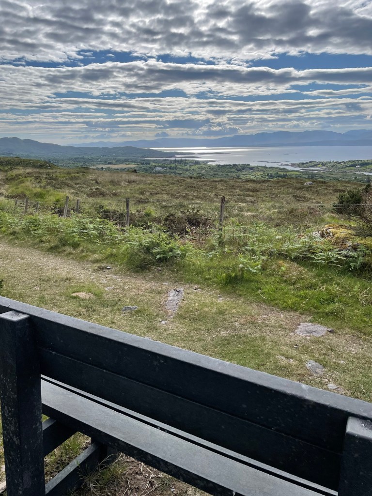
But, but, but … A point in favour of my way of doing it that I realized as I was finishing was that the scenery just gets better and better as you go – the stretch from Cahersiveen to Killarney is wonderful, especially if you get clear days as I did.
If you go in the guidebook direction, then the best scenery is upfront. I’d rather delay the payoff, as it were, but that’s just me.

*****
The first day out of Kenmare took me through all the trail conditions I would encounter for the rest of the way – muddy, boggy, rocky, grassy, gravelly, sheep-ploppy, and cow-floppy, with all the combinations thereof. My favourite was a stretch of grassy-muddy-boggy-sheep ploppy-cow floppy conditions that threatened to fill my boots again with mucky water.

It rained more or less all day, sometimes easing off only to come down harder later. I took it in stride, however, happy to be walking after my near-disaster, and made good progress to reach a pretty stretch of the Way right by the shores of Kenmare Bay near Lackeen Point.

I had planned to wild camp in this area but could find nothing level enough, or far enough off the trail, to work, so I kept going and eventually came upon a good spot sheltered by trees near Blackwater Bridge.

It rained all that night, making for a very wet stay, but it was pleasant enough listening to the birds, the plop of rain drops, and the murmur of the Black River nearby.
The next day I set off towards Sneem, relieved to find in the morning that the rain had finally cleared. It was a gently taxing walk, some hills and muck but no real challenges, yet still long enough to bring on an appetite by the time I reached Sneem.
I had lunch at the Village Cafe, just getting in ahead of a bus load of tourists, and sat outside to dry my tent a bit while I had tea and a sandwich. Several tourists stopped to ask where I was walking, was I camping, what was it like, etc. But the locals ignored the tourists, including me.
From Sneem I continued on, intending to camp off the trail in a stretch of forest about halfway to Caherdaniel which, on the map at least, seemed promising. But upon reaching it, I could see that the ground sloped far too much to offer any hope of level ground. Not for the last time, I was forced to keep on walking, down a steep, rocky, slippery hill and on towards Caherdaniel.

I had thoughts of going on to that town that evening because I knew there were a couple of B&Bs, but with about 5km to go and after about 10 hours of walking, I ran out of energy near the hamlet of Castle Cove. I left the Way there and walked into the town where I eventually found a spot to camp for the night, in a deserted caravan park.
The next morning, I was up early to sunshine and a fresh breeze, which helped me on to Caherdaniel. I’d hoped to find a little cafe which might at least offer tea and perhaps a full breakfast, but there were only a couple of pubs, neither yet open.
Leaving Caherdaniel, the Kerry Way offers two options, one longer but with less climbing along the coast, or the one which I took, shorter but hillier.
The sun was out and the views were lovely as the Way left the rough tracks across hillside sheep pastures behind, and instead followed wee back roads into Waterville.
I reached town in good time and checked into a B&B after two nights of camping, pleased to be able to wash some socks and have a very welcome hot shower, after drinking a lovely cup of tea. A pleasant meal sitting by the seashore rounded out the day.
While sipping my beer that night, I studied the map. From Waterville, I had two choices. Following the Kerry Way involved a 30+ km stretch to reach Cahersiveen that had 860+ meters of climb and descent in it, much of it along the spine of a mountain ridge.
The views would be lovely (assuming clear weather), but there was no chance of camping along there given the exposed slopes, and since I knew I would struggle to do that stretch in a single day, it posed a very tough challenge.
Instead, I opted to follow the coast road out of Waterville towards Ballinskellig, which offered a lovely 2km beach walk,

and then took the Skelligs Ring route on back roads to reach St Finan’s Bay.
After a rest there and a delicious bowl of seafood chowder at the Driftwood Surf Cafe, I continued along the road out of the village towards Portmagee, which took me up a steep switchbacked 250m hill climb,
but cresting the hill offered gorgeous views,
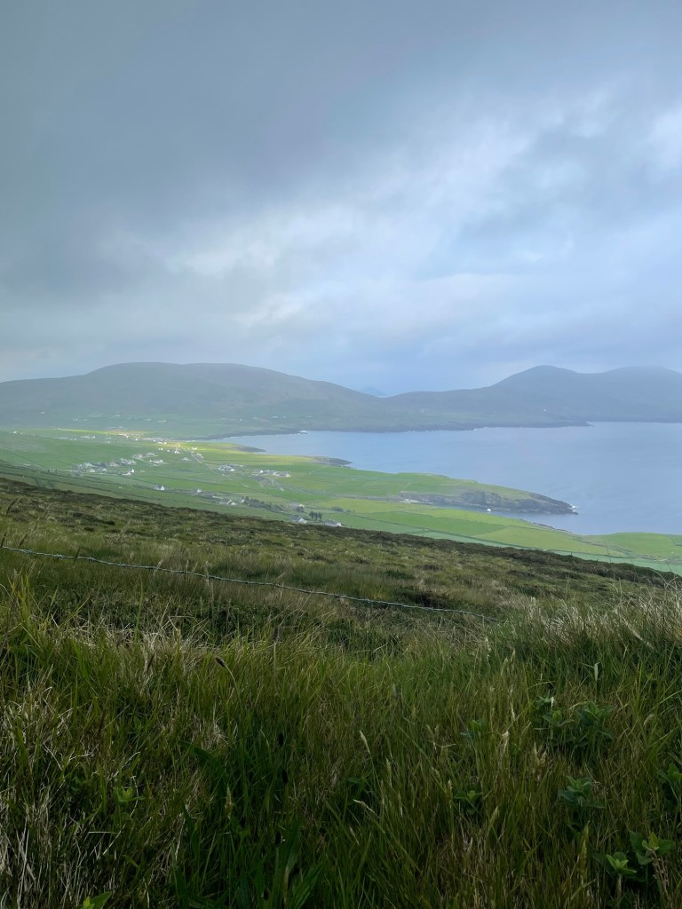
And in coming down from that I reached the Kerry Cliffs.
This privately owned tourist attraction is well situated on rugged coastline offering stupendous views westwards from cliff tops 80 m above the churning sea.

I camped there right up on the cliff tops, nervous about the wind, but snug enough tucked under a turf bank.

The next morning took me down into Portmagee for yet another great Irish vegetarian breakfast and tea. The bridge to Valentia Island beckoned, and I followed back roads along the length of the island to reach the delightful Knightstown, (strangely reminiscent of Cornwall – must have been the palm trees). I recharged there with a very good flat white made by an Irish guy who remarked that the Aussies had nothing to teach him about the art of making coffee.
The ferry ride from Knightstown back to the mainland is short, less than a km, reminiscent in this case of the Lehave River ferry back home in Nova Scotia.

When I stepped off the ferry I had only a short 4 km walk to reach Cahersiveen, arriving early in the afternoon as the sun was coming out.
The Mannix Point campground there was fantastic, the best I’ve stayed in, and I happily lounged about doing some laundry, having a shower, reading, and just relaxing.
The weather was glorious that evening, warm and sunny, and forecast to remain so for a couple days. If I hadn’t wanted to see more of the Kerry Way I would have stayed there for a bit.
But the trail tugged at me, as it always does.
Stories Along The Way
Walking out of Kenmare, it was dry(ish) but there was rain in the air. I hadn’t gotten more than about a km up the hill when the first drops confirmed my intuition.
I pulled out my rain poncho, which I hadn’t worn the day during my soaked walk into Kenmare, since I was already wet to the skin by the time I had a chance to put it on.
It took a minute to figure out how to get it on over me and over my backpack – the trick, I realized, was to stand facing the wind and let the breeze carry it up and over my shoulders and then quickly spin around as I pulled it down so the wind held it against my back.
I had it settled after a bit of wrestling, and continued up the hill. I wore it the rest of the day, congratulating myself on my choice of rain gear since it was much lighter in weight than my previous rain jacket but at the same time allowed more ventilation, especially when worn with shorts.
As I walked I thought that the clever hiker would have a spare boot lace (I did!) and a carabiner or two (I did again!!) and could use those to fashion a simple belt to hold the bottom of the poncho down against any strong gusts.
And then I thought the really, really clever hiker would have had the idea before he put the poncho on and had the belt ready in a convenient pocket. Oh well.
*****
I must confess that I did try to put the poncho on during that wild Monday morning. But the best method I can see for donning a rain poncho in a gale is:
- Get out poncho
- Spend 5 minutes attempting to don it while the wind swirls it in all directions threatening to alternately smother you and blind you (cursing is optional during this step)
- Give up and resign yourself to getting wet
*****
When I reached Cahersiveen, I was pleased to see that there were laundry facilities at the campground I was in. I wanted to wash everything that I could, including my sleep clothes, which meant that the only remaining clothes that I had to wear were a T-shirt and a pair of underwear.
So I improvised. I tossed everything into the machine, and waited for it to finish wearing my windbreaker as a kilt.
Very fashionable amongst the hiking set, I’m told.
*****
Walking from Caherdaniel to Waterville, I was passing along a nice stretch of the trail, facing a charming blue sea set off by the green of the hills sloping down towards it.
This was one of those spots where a bench had been placed, and I took advantage to sit for a few minutes and have a sip of water.
I was minding my own business when I noticed another hiker coming towards me. She also noticed the bench and made for it. I waited, not wanting to seem rude, as if I was getting up to avoid her.
She sat down and we struck up a conversation. She was German, and perhaps (though a gentleman never speculates about a lady’s age) of about my vintage. We remarked on the trail and the scenery and the weather, and then she said, looking at the shorts I was wearing, “that is a good idea, it is getting warm now”.
And she reached down to unzip the legs off her trousers – they converted into shorts you see – and pulled off one leg and then the other to reveal, ahem, rather shapely legs.
I looked away, not to seem as if I was leering, and coughed and excused myself and headed on my way.
And later I thought, that was like that scene in The Graduate. She was Mrs Robinson, so I must be Benjamin. And she did kind of look like Anne Bancroft. Hey, maybe I’ve still got it. It’s that #hikerDude mystique. Gotta be …
I walked off humming the Simon and Garfunkel hit song from that movie.
“And here’s to you, Mrs Robinson, Jesus loves you more than you can know” ….
*****
When I reached Castle Cove, I passed by a pub and restaurant that had a big Accommodations sign out front. I went in and was through a seemingly deserted interior, calling out Hello. Eventually a woman came out of the back, and replied to my inquiry that they weren’t doing accommodation just then.
I asked if I could set up my tent in their garden, since there appeared to be about a half acre of grass there. “No”, she said. Just that. Hmm, ok. “Do you know of anywhere nearby where I can camp?”. “Right down the road, just go down to the main road, turn right and cross the bridge, and it’s the first entrance, there’s a campground there.”
So I thanked her and went next door, into was not a campground so much as a caravan park, and a deserted one at that. I walked round the place, not a soul in sight, no cars, nothing to indicate that any of the units were occupied. And there was no office either, just a big sign that said “You are under CCTV Surveillance “.
I returned to the pub and knocked, and reported my findings. Can I camp there? It’s not a campground, there’s no one round to ask, and the sign says No Trespassing. And there’s no water outlets anywhere.
“Yes”, she said, “it’s fine. Just set up on any patch of grass and you’ll be ok”. Hmm, alright, “can you please fill my water container then”. She grudgingly did so, and turned away, obviously dismissing me.
I walked back, and wandered around some more, finally settling on a relatively secluded spot that wasn’t too obvious from the road. As I started to set up my tent I realized I had forgotten my trekking poles back at the pub. Trudge over, trudge back. Finally my tent is set up.
I groan as I take off my boots and crawl in, arrange my gear, break out my cooking gear, and start to boil water for my meal. I just get dinner ready when …
Wait for it …
A large tractor pulls into the park and starts cutting the grass.
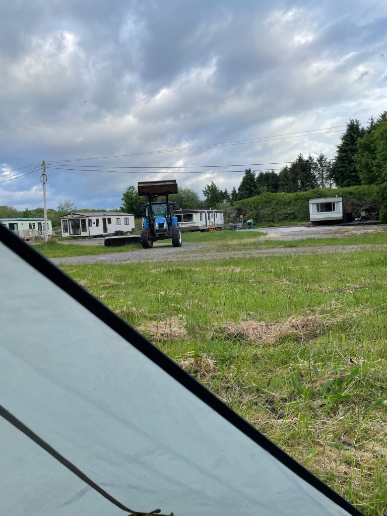
It’s roaring away and slowly getting closer to where I am set up. The driver eventually sees me. I think about going out to tell him that the lady next door said I could camp here. To hell with it, I think. I’m tired, I’m damned if I’m moving my tent at this point, and I just want him to finish so I can go to bed.
He eventually does all the grass that he can except for my patch, coming within about 10m of me. He gives me one last look, and heads off. I can see him on his phone as he drives away.
I go to bed expecting the Garda to show up in the dark to haul me off for trespassing. But there’s no further disturbance, except for the squawks of angry crows. Céad míle fáilte my arse.
Where to Next?
From Cahersiveen, I walked the second half (my version that is) of the Kerry Way to return to Killarney. More on that later.
Like what you read? Buy me a coffee. Your donation helps offset the costs of maintaining this blog.
